
Le Bourg topographic map
Interactive map
Click on the map to display elevation.
About this map
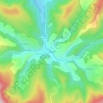
Name: Le Bourg topographic map, elevation, terrain.
Average elevation: 3,104 ft
Minimum elevation: 2,444 ft
Maximum elevation: 4,324 ft
Other topographic maps
Click on a map to view its topography, its elevation and its terrain.
Les Bascous
France > Auvergne-Rhône-Alpes > Drôme > Valdrôme
Les Bascous, Valdrôme, Die, Drôme, Auvergne-Rhône-Alpes, France métropolitaine, 26310, France
Average elevation: 3,812 ft
Vaugelas
France > Auvergne-Rhône-Alpes > Drôme > Valdrôme
Vaugelas, Valdrôme, Die, Drôme, Auvergne-Rhône-Alpes, France métropolitaine, 26310, France
Average elevation: 3,163 ft