
Santa Margarita topographic map
Interactive map
Click on the map to display elevation.
About this map
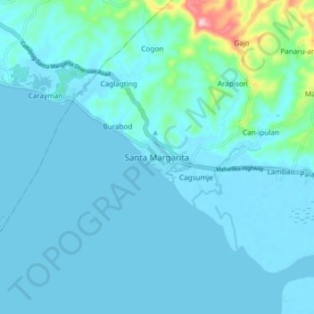
Name: Santa Margarita topographic map, elevation, terrain.
Location: Santa Margarita, Samar, Eastern Visayas, 6718, Philippines (11.99799 124.61779 12.07799 124.69779)
Average elevation: 75 ft
Minimum elevation: -7 ft
Maximum elevation: 794 ft
Other topographic maps
Click on a map to view its topography, its elevation and its terrain.
Cagsumje
Philippines > Samar > Santa Margarita
Cagsumje, Santa Margarita, Samar, Eastern Visayas, 6718, Philippines
Average elevation: 33 ft