
Thank you for supporting this site ❤️
Make a donation
Make a donation
Gear up for your next adventure:
As an Amazon Associate, this site earns from qualifying purchases at no extra cost to you.
Malente topographic map
Click on the map to display elevation.
Thank you for supporting this site ❤️
Make a donation
Make a donation
Gear up for your next adventure:
As an Amazon Associate, this site earns from qualifying purchases at no extra cost to you.
About this map
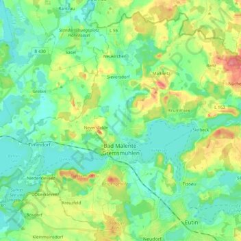
Name: Malente topographic map, elevation, terrain.
Location: Malente, Ostholstein, Schleswig-Holstein, 23714, Germany (54.13266 10.48294 54.23544 10.67612)
Average elevation: 138 ft
Minimum elevation: 59 ft
Maximum elevation: 318 ft
Thank you for supporting this site ❤️
Make a donation
Make a donation
Gear up for your next adventure:
As an Amazon Associate, this site earns from qualifying purchases at no extra cost to you.
Other topographic maps
Click on a map to view its topography, its elevation and its terrain.
Pelzerhaken
Germany > Schleswig-Holstein > Ostholstein > Neustadt in Holstein
Average elevation: 26 ft