
Acherito topographic map
Interactive map
Click on the map to display elevation.
About this map
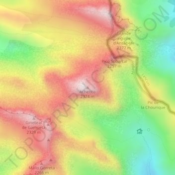
Name: Acherito topographic map, elevation, terrain.
Location: Acherito, Ansó, La Jacetania, Huesca, Aragón, España (42.89140 -0.73727 42.89150 -0.73717)
Average elevation: 6,512 ft
Minimum elevation: 5,217 ft
Maximum elevation: 7,687 ft
Other topographic maps
Click on a map to view its topography, its elevation and its terrain.
Ibón de Acherito
España > Aragón > La Jacetania > Ansó
Ibón de Acherito, Ansó, La Jacetania, Huesca, Aragón, España
Average elevation: 5,856 ft