
Rochefort topographic map
Interactive map
Click on the map to display elevation.
About this map
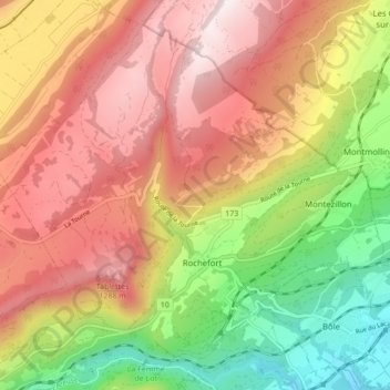
Name: Rochefort topographic map, elevation, terrain.
Location: Rochefort, Neuchâtel, 2019, Suisse (46.96226 6.76243 47.01378 6.84849)
Average elevation: 3,143 ft
Minimum elevation: 1,509 ft
Maximum elevation: 4,619 ft
Elle se situe à une altitude moyenne de 999 m. Son point le plus bas se situe dans les Gorges de l'Areuse (523 m) alors qu'elle atteint les 1 390 m à son point culminant, au nord des Cucheroud-Dessus.
Other topographic maps
Click on a map to view its topography, its elevation and its terrain.
Les Grattes
Suisse > Neuchâtel > Rochefort
Les Grattes, Rochefort, Neuchâtel, 2019, Suisse
Average elevation: 3,018 ft