
Kempten (Allgäu) topographic map
Interactive map
Click on the map to display elevation.
About this map
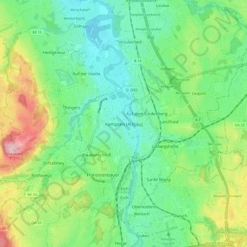
Name: Kempten (Allgäu) topographic map, elevation, terrain.
Location: Kempten (Allgäu), Bavaria, 87435, Germany (47.68671 10.27688 47.76671 10.35688)
Average elevation: 2,402 ft
Minimum elevation: 2,119 ft
Maximum elevation: 3,031 ft
Other topographic maps
Click on a map to view its topography, its elevation and its terrain.
Kempten (Allgäu)
Germany > Bavaria > Kempten (Allgäu)
Kempten (Allgäu), Bavaria, Germany
Average elevation: 2,418 ft