
Make a donation
Gear up for your next adventure:
As an Amazon Associate, this site earns from qualifying purchases at no extra cost to you.
Kilolo topographic map
Click on the map to display elevation.
Make a donation
Gear up for your next adventure:
As an Amazon Associate, this site earns from qualifying purchases at no extra cost to you.
About this map
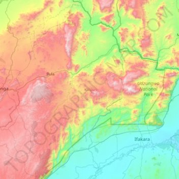
Name: Kilolo topographic map, elevation, terrain.
Location: Kilolo, Iringa Region, Southern Highlands Zone, Tanzania (-8.40280 35.58758 -7.17060 36.84564)
Average elevation: 3,412 ft
Minimum elevation: 778 ft
Maximum elevation: 8,386 ft
Make a donation
Gear up for your next adventure:
As an Amazon Associate, this site earns from qualifying purchases at no extra cost to you.
Other topographic maps
Click on a map to view its topography, its elevation and its terrain.
Iringa
The town stretches along a hilltop overlooking the Little Ruaha River to the south, and spreads along ridges and valleys to the north. Iringa is in the Udzungwa Mountains, and the altitude of the town's environs is more than 1,550 metres (5,090 ft) above sea level. The months of June, July, and August can see…
Average elevation: 5,154 ft
Make a donation
Gear up for your next adventure:
As an Amazon Associate, this site earns from qualifying purchases at no extra cost to you.
Make a donation
Gear up for your next adventure:
As an Amazon Associate, this site earns from qualifying purchases at no extra cost to you.