
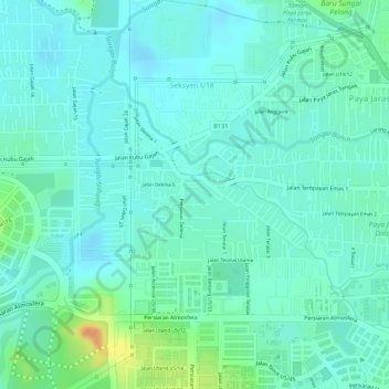
Paya Jaras Hilir topographic map
Interactive map
Click on the map to display elevation.
About this map
Name: Paya Jaras Hilir topographic map, elevation, terrain.
Average elevation: 85 ft
Minimum elevation: 46 ft
Maximum elevation: 190 ft
Other topographic maps
Click on a map to view its topography, its elevation and its terrain.
Sungai Buloh New Village
Malaysia > Selangor > Shah Alam > Sungai Buloh
Sungai Buloh New Village, Sungai Buloh, Shah Alam, Petaling, Selangor, Malaysia
Average elevation: 128 ft
Kampung Batu 4
Malaysia > Selangor > Shah Alam > Sungai Buloh
Kampung Batu 4, Sungai Buloh, Shah Alam, Petaling, Selangor, 40160, Malaysia
Average elevation: 118 ft
Kampung Baru Sungai Pelong
Malaysia > Selangor > Shah Alam > Sungai Buloh > Kampung Baru Sungai Pelong
Kampung Baru Sungai Pelong, Sungai Buloh, Shah Alam, Selangor, 40160, Malaysia
Average elevation: 125 ft