
Wolfbühl topographic map
Interactive map
Click on the map to display elevation.
About this map
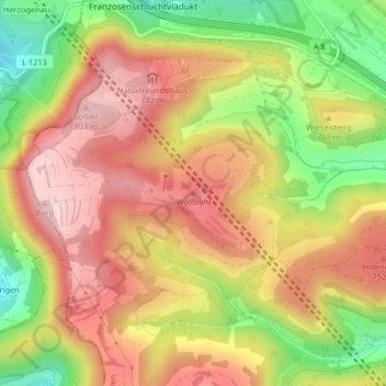
Name: Wolfbühl topographic map, elevation, terrain.
Average elevation: 2,270 ft
Minimum elevation: 1,781 ft
Maximum elevation: 2,641 ft
Other topographic maps
Click on a map to view its topography, its elevation and its terrain.
Boßler
Deutschland > Baden-Württemberg > Landkreis Göppingen > Gruibingen
Boßler, Gruibingen, Gemeindeverwaltungsverband Oberes Filstal, Landkreis Göppingen, Baden-Württemberg, 73087, Deutschland
Average elevation: 2,096 ft