
Tarrasa topographic map
Interactive map
Click on the map to display elevation.
About this map
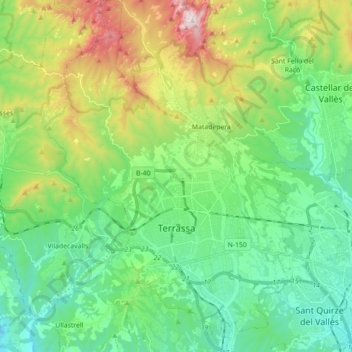
Name: Tarrasa topographic map, elevation, terrain.
Location: Tarrasa, Vallés Occidental, Barcelona, Cataluña, 08221, España (41.51630 1.94358 41.64872 2.06882)
Average elevation: 1,257 ft
Minimum elevation: 305 ft
Maximum elevation: 3,576 ft
Other topographic maps
Click on a map to view its topography, its elevation and its terrain.
Font d’en Fargues
España > Vallés Occidental > Sentmenat
Font d’en Fargues, Camí de Guanta, Sentmenat, Vallés Occidental, Barcelona, 08181, España
Average elevation: 1,001 ft
Santa Perpètua de Mogoda
Santa Perpètua de Mogoda, Vallés Occidental, Barcelona, Cataluña, 08130, España
Average elevation: 299 ft