
Isla de los Faisanes topographic map
Interactive map
Click on the map to display elevation.
About this map
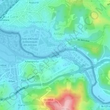
Name: Isla de los Faisanes topographic map, elevation, terrain.
Average elevation: 141 ft
Minimum elevation: -20 ft
Maximum elevation: 732 ft
Other topographic maps
Click on a map to view its topography, its elevation and its terrain.
Belaskoenea
España > País Vasco > Irún > Belaskoenea
Belaskoenea, Irún, Bajo Bidasoa, Guipúzcoa, País Vasco, 20305, España
Average elevation: 125 ft