Geolocate

Oleiros topographic map

Click on the map to display elevation.

About this map

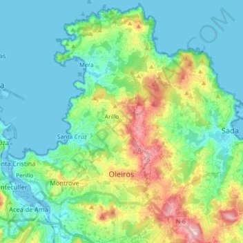
Name: Oleiros topographic map, elevation, terrain.

Location: Oleiros, A Coruña, Galicia, Spain (43.30385 -8.38372 43.40698 -8.29570)

Average elevation: 161 ft

Minimum elevation: -3 ft

Maximum elevation: 640 ft

Gear up for your next adventure:

🌄Hiking Binoculars - Compact binoculars for scenic views and trail spotting
🔊Portable Camp Speaker - Music and alerts at camp
🪶Paracord Bracelet - Survival bracelet with built‑in tools
📻Weather Alert Radios - Stay informed of storm risks while off-the-grid
🎒Hydration Pack - Hands‑free water reservoir for long hikes

As an Amazon Associate, this site earns from qualifying purchases at no extra cost to you.