
Thank you for supporting this site ❤️
Make a donation
Make a donation
Gear up for your next adventure:
As an Amazon Associate, this site earns from qualifying purchases at no extra cost to you.
Castro-Urdiales topographic map
Click on the map to display elevation.
Thank you for supporting this site ❤️
Make a donation
Make a donation
Gear up for your next adventure:
As an Amazon Associate, this site earns from qualifying purchases at no extra cost to you.
About this map
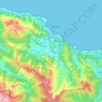
Name: Castro-Urdiales topographic map, elevation, terrain.
Location: Castro-Urdiales, Costa Oriental, Cantabria, Spain (43.28360 -3.33526 43.41913 -3.14965)
Average elevation: 620 ft
Minimum elevation: -3 ft
Maximum elevation: 2,690 ft
Thank you for supporting this site ❤️
Make a donation
Make a donation
Gear up for your next adventure:
As an Amazon Associate, this site earns from qualifying purchases at no extra cost to you.