
Tannheim topographic map
Interactive map
Click on the map to display elevation.
About this map
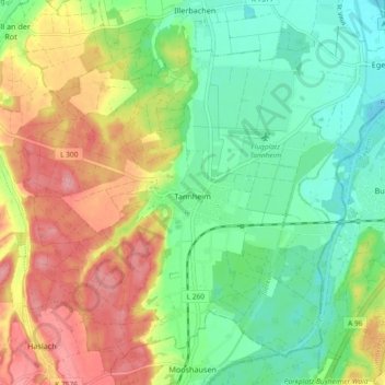
Name: Tannheim topographic map, elevation, terrain.
Average elevation: 1,988 ft
Minimum elevation: 1,841 ft
Maximum elevation: 2,195 ft
Other topographic maps
Click on a map to view its topography, its elevation and its terrain.
Heiligkreuztal
Duitsland > Baden-Württemberg > Landkreis Biberach
Heiligkreuztal, Altheim, Gemeindeverwaltungsverband Riedlingen, Landkreis Biberach, Baden-Württemberg, 88515, Duitsland
Average elevation: 1,870 ft