
Santa Rosa de Lima topographic map
Interactive map
Click on the map to display elevation.
About this map
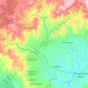
Name: Santa Rosa de Lima topographic map, elevation, terrain.
Location: Santa Rosa de Lima, Santa Rosa, Guatemala (14.36795 -90.41544 14.50515 -90.25741)
Average elevation: 4,357 ft
Minimum elevation: 2,972 ft
Maximum elevation: 6,667 ft
Other topographic maps
Click on a map to view its topography, its elevation and its terrain.
Guazacapán
Guatemala > Santa Rosa > Guazacapán
Guazacapán, Santa Rosa, Guatemala
Average elevation: 627 ft