
大河家镇 topographic map
Interactive map
Click on the map to display elevation.
About this map
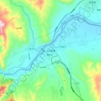
Name: 大河家镇 topographic map, elevation, terrain.
Location: 大河家镇, 积石山保安族东乡族撒拉族自治县, 临夏回族自治州, 甘肃省, 中国 (35.79619 102.71844 35.87619 102.79844)
Average elevation: 6,388 ft
Minimum elevation: 5,778 ft
Maximum elevation: 8,428 ft
Other topographic maps
Click on a map to view its topography, its elevation and its terrain.
小洼
中国 > 甘肃省 > 积石山保安族东乡族撒拉族自治县 > 马家村
小洼, 马家村, 积石山保安族东乡族撒拉族自治县, 临夏回族自治州, 甘肃省, 中国
Average elevation: 7,218 ft