
Kidsgrove topographic map
Interactive map
Click on the map to display elevation.
About this map
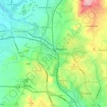
Name: Kidsgrove topographic map, elevation, terrain.
Average elevation: 528 ft
Minimum elevation: 259 ft
Maximum elevation: 1,083 ft
Other topographic maps
Click on a map to view its topography, its elevation and its terrain.
Swan Bank
United Kingdom > England > Staffordshire > Newcastle-under-Lyme > Madeley Heath
Swan Bank, Madeley, Madeley Heath, Newcastle-under-Lyme, Staffordshire, England, CW3 9JY, United Kingdom
Average elevation: 443 ft
Keele
United Kingdom > England > Staffordshire > Newcastle-under-Lyme
Keele, Newcastle-under-Lyme, Staffordshire, England, United Kingdom
Average elevation: 545 ft
The Moss
United Kingdom > England > Staffordshire > Newcastle-under-Lyme > Madeley > The Moss
The Moss, Madeley, Newcastle-under-Lyme, Staffordshire, West Midlands, England, CW3 9NN, United Kingdom
Average elevation: 400 ft