
Ascalon topographic map
Interactive map
Click on the map to display elevation.
About this map
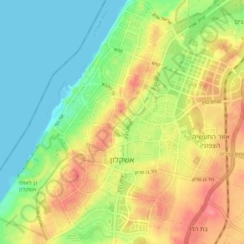
Name: Ascalon topographic map, elevation, terrain.
Location: Ascalon, sous-district d'Ashkelon, District sud, Israël (31.64270 34.54782 31.70559 34.60656)
Average elevation: 102 ft
Minimum elevation: 0 ft
Maximum elevation: 226 ft
Other topographic maps
Click on a map to view its topography, its elevation and its terrain.
גן לאומי מצדה
Israël > District sud > Arad
גן לאומי מצדה, 3199, Arad, no, Israël
Average elevation: -112 ft
Omer
Omer, sous-district de Beer-Sheva, District sud, Israël
Average elevation: 1,099 ft