
Belvedere topographic map
Interactive map
Click on the map to display elevation.
About this map
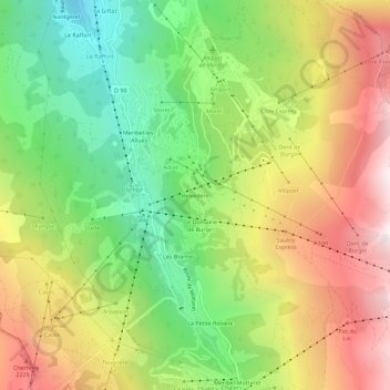
Name: Belvedere topographic map, elevation, terrain.
Average elevation: 5,951 ft
Minimum elevation: 4,039 ft
Maximum elevation: 8,219 ft
Other topographic maps
Click on a map to view its topography, its elevation and its terrain.
Meribel-les-Allues
Frankreich > Auvergne-Rhone-Alpen > Savoyen > Les Allues
Meribel-les-Allues, Les Allues, Albertville, Savoyen, Auvergne-Rhone-Alpen, Metropolitanes Frankreich, 73550, Frankreich
Average elevation: 5,643 ft