
Vérolliez topographic map
Interactive map
Click on the map to display elevation.
About this map
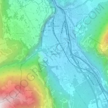
Name: Vérolliez topographic map, elevation, terrain.
Location: Vérolliez, Saint-Maurice, Valais, 1890, Suisse (46.18521 6.98230 46.22521 7.02230)
Average elevation: 2,503 ft
Minimum elevation: 1,332 ft
Maximum elevation: 6,453 ft
Other topographic maps
Click on a map to view its topography, its elevation and its terrain.
Saint-Maurice
Suisse > Valais > Saint-Maurice > Saint-Maurice
Saint-Maurice, Valais, 1890, Suisse
Average elevation: 2,641 ft