
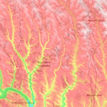
Murovani Kurylivtsi Settlement Hromada topographic map
Interactive map
Click on the map to display elevation.
About this map
Name: Murovani Kurylivtsi Settlement Hromada topographic map, elevation, terrain.
Average elevation: 846 ft
Minimum elevation: 220 ft
Maximum elevation: 1,184 ft
Other topographic maps
Click on a map to view its topography, its elevation and its terrain.
Subotivka
Subotivka, Mohyliv-Podilskyi Urban Hromada, Mohyliv-Podilskyi Raion, Vinnytsia Oblast, 24060, Ukraine
Average elevation: 430 ft
Humenne
Humenne, Voronovytsia Settlement Hromada, Vinnytsia Raion, Vinnytsia Oblast, 23203, Ukraine
Average elevation: 948 ft
Havryshivka
Havryshivka, Vinnytsia Urban Hromada, Vinnytsia Raion, Vinnytsia Oblast, 23202, Ukraine
Average elevation: 925 ft
Salnyk
Salnyk, Kalynivka Urban Hromada, Khmilnyk Raion, Vinnytsia Oblast, Ukraine
Average elevation: 866 ft
Urozhaine
Urozhaine, Hnivan Urban Hromada, Vinnytsia Raion, Vinnytsia Oblast, Ukraine
Average elevation: 876 ft
Koziatyn
Koziatyn, Koziatyn Urban Hromada, Khmilnyk Raion, Vinnytsia Oblast, Ukraine
Average elevation: 961 ft
Kopaihorod Settlement Hromada
Kopaihorod Settlement Hromada, Zhmerynka Raion, Vinnytsia Oblast, Ukraine
Average elevation: 968 ft
Pidlisne
Pidlisne, Stryzhavka Settlement Hromada, Vinnytsia Raion, Vinnytsia Oblast, 22337, Ukraine
Average elevation: 942 ft
Shumy
Shumy, Horodkivka Rural Hromada, Tulchyn Raion, Vinnytsia Oblast, 24623, Ukraine
Average elevation: 551 ft
Vinnytsia
Vinnytsia, Vinnytsia Urban Hromada, Vinnytsia Raion, Vinnytsia Oblast, Ukraine
Average elevation: 899 ft
Maidan-Chapelskyi
Maidan-Chapelskyi, Luka-Meleshkivska Rural Hromada, Vinnytsia Raion, Vinnytsia Oblast, Ukraine
Average elevation: 1,017 ft
Haisyn
Ukraine > Vinnytsia Oblast > Haisyn
Haisyn, Haisyn Urban Hromada, Haisyn Raion, Vinnytsia Oblast, 23700-23705, Ukraine
Average elevation: 686 ft
Vinnytsia
Ukraine > Vinnytsia Oblast > Vinnytsia
Vinnytsia, Vinnytsia City Hromada, Vinnytsia Raion, Vinnytsia Oblast, 21000-21499, Ukraine
Average elevation: 892 ft
Pohrebysche
Ukraine > Vinnytsia Oblast > Pohrebysche
Pohrebysche, Pohrebyshche Raion, Vinnytsia Oblast, Ukraine
Average elevation: 787 ft
Haisyn
Haisyn, Haisyn Urban Hromada, Haisyn Raion, Vinnytsia Oblast, 23700, Ukraine
Average elevation: 663 ft
Velykyi Step
Velykyi Step, Samhorodok Rural Hromada, Khmilnyk Raion, Vinnytsia Oblast, Ukraine
Average elevation: 1,017 ft