
磨黑镇 topographic map
Interactive map
Click on the map to display elevation.
About this map
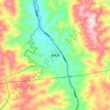
Name: 磨黑镇 topographic map, elevation, terrain.
Location: 磨黑镇, 宁洱哈尼族彝族自治县, 普洱市, 云南省, 665000, 中国 (23.11620 101.12100 23.19620 101.20100)
Average elevation: 4,990 ft
Minimum elevation: 3,743 ft
Maximum elevation: 6,512 ft
Other topographic maps
Click on a map to view its topography, its elevation and its terrain.
东洱河水库
中国 > 云南省 > 宁洱哈尼族彝族自治县 > 宁洱县
东洱河水库, 宁洱县, 宁洱哈尼族彝族自治县, 普洱市, 云南省, 665000, 中国
Average elevation: 4,524 ft