
دهستان گلهدار topographic map
Interactive map
Click on the map to display elevation.
About this map
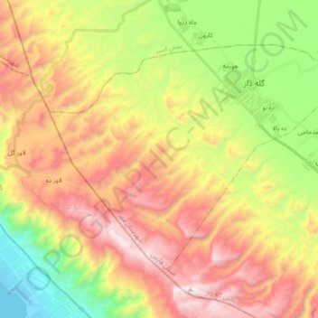
Name: دهستان گلهدار topographic map, elevation, terrain.
Location: دهستان گلهدار, بخش گله دار, Mohr County, Fars Province, Iran (27.57195 52.55077 27.68146 52.72197)
Average elevation: 2,362 ft
Minimum elevation: -7 ft
Maximum elevation: 4,885 ft
Other topographic maps
Click on a map to view its topography, its elevation and its terrain.
Mohr
Iran > Fars Province > Mohr County
Mohr, بخش مرکزی, Mohr County, Fars Province, Iran
Average elevation: 1,453 ft