
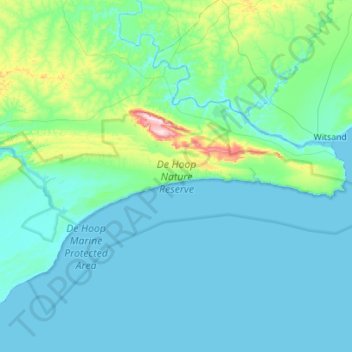
De Hoop Nature Reserve topographic map
Interactive map
Click on the map to display elevation.
About this map
Name: De Hoop Nature Reserve topographic map, elevation, terrain.
Average elevation: 207 ft
Minimum elevation: -7 ft
Maximum elevation: 1,906 ft
Other topographic maps
Click on a map to view its topography, its elevation and its terrain.
Bredasdorp
South Africa > Western Cape > Overberg District Municipality > Cape Agulhas Local Municipality
Bredasdorp, Cape Agulhas Local Municipality, Overberg District Municipality, Western Cape, 7280, South Africa
Average elevation: 341 ft
Arniston
South Africa > Western Cape > Overberg District Municipality > Cape Agulhas Local Municipality
Arniston, Cape Agulhas Local Municipality, Overberg District Municipality, Western Cape, South Africa
Average elevation: 43 ft
Struisbaai
South Africa > Western Cape > Overberg District Municipality > Cape Agulhas Local Municipality > Molshoop
Struisbaai, Cape Agulhas Ward 5, Molshoop, Cape Agulhas Local Municipality, Overberg District Municipality, Western Cape, 7285, South Africa
Average elevation: 89 ft
Bredasdorp
South Africa > Western Cape > Overberg District Municipality > Cape Agulhas Local Municipality
Bredasdorp, Cape Agulhas Local Municipality, Overberg District Municipality, Western Cape, 7280, South Africa
Average elevation: 331 ft
Skipskop
South Africa > Western Cape > Overberg District Municipality > Cape Agulhas Local Municipality
Skipskop, Cape Agulhas Ward 4, Cape Agulhas Local Municipality, Overberg District Municipality, Western Cape, South Africa
Average elevation: 33 ft
De Mond Nature Reserve
South Africa > Western Cape > Overberg District Municipality > Cape Agulhas Local Municipality
De Mond Nature Reserve, Gravel Road, Cape Agulhas Ward 6, Cape Agulhas Local Municipality, Overberg District Municipality, Western Cape, South Africa
Average elevation: 16 ft