
Darrenwood Park topographic map
Interactive map
Click on the map to display elevation.
About this map
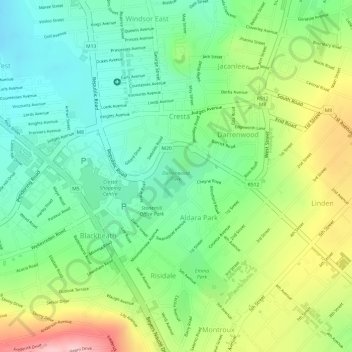
Name: Darrenwood Park topographic map, elevation, terrain.
Average elevation: 5,243 ft
Minimum elevation: 5,000 ft
Maximum elevation: 5,617 ft
Other topographic maps
Click on a map to view its topography, its elevation and its terrain.
Chartwell Gardens
South Africa > Gauteng > City of Johannesburg Metropolitan Municipality > Johannesburg
Chartwell Gardens, Killarney, Johannesburg Ward 73, Johannesburg, City of Johannesburg Metropolitan Municipality, Gauteng, 2001, South Africa
Average elevation: 5,587 ft