Geolocate

Centerville topographic map

Click on the map to display elevation.

About this map

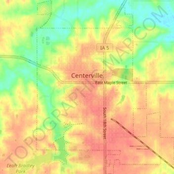
Name: Centerville topographic map, elevation, terrain.

Location: Centerville, Appanoose County, Iowa, 52544, United States (40.70811 -92.89205 40.75446 -92.84358)

Average elevation: 961 ft

Minimum elevation: 856 ft

Maximum elevation: 1,033 ft

Appanoose County trails, hiking, mountain biking, running and outdoor activities

Other topographic maps

Click on a map to view its topography, its elevation and its terrain.

Moravia

United States > Iowa > Appanoose County > Moravia > Moravia

Average elevation: 978 ft

Gear up for your next adventure:

🧯Emergency Survival Kit - All‑in‑one survival essentials for the backcountry
🎒Hydration Pack - Hands‑free water reservoir for long hikes
🔊Portable Camp Speaker - Music and alerts at camp
🍳Camping Cook Set - Complete cookware for outdoor meals
📦Dry Bags Set - Waterproof storage for electronics and clothes

As an Amazon Associate, this site earns from qualifying purchases at no extra cost to you.