
Río Tapiche topographic map
Interactive map
Click on the map to display elevation.
About this map
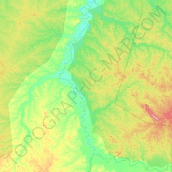
Name: Río Tapiche topographic map, elevation, terrain.
Location: Río Tapiche, Alto Tapiche, Requena, Loreto, Perú (-6.96307 -74.40731 -6.64479 -74.13196)
Average elevation: 581 ft
Minimum elevation: 423 ft
Maximum elevation: 860 ft
Other topographic maps
Click on a map to view its topography, its elevation and its terrain.
Parque Nacional Sierra del Divisor
Perú > Loreto > Alto Tapiche
Parque Nacional Sierra del Divisor, Perú
Average elevation: 640 ft
Provincia de Requena
Perú > Loreto > Alto Tapiche
Provincia de Requena, Alto Tapiche, Requena, Loreto, Perú
Average elevation: 344 ft