Geolocate

Fleet topographic map

Click on the map to display elevation.

About this map
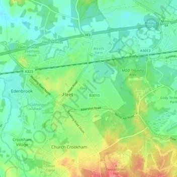
Name: Fleet topographic map, elevation, terrain.

Location: Fleet, Hart, Hampshire, England, United Kingdom (51.26322 -0.87594 51.30238 -0.79030)

Average elevation: 249 ft

Minimum elevation: 184 ft

Maximum elevation: 387 ft

Other topographic maps

Click on a map to view its topography, its elevation and its terrain.
Brookly Stream

United Kingdom > England > Hampshire > Hart > Fleet

Average elevation: 256 ft

Gear up for your next adventure:

🏥Hiking First Aid Kits - Comprehensive medical kits for remote trail injuries
🧴Hand Sanitizer - Keep hands clean while hiking
💧Water Filtration Bottles - Safely drink from streams and lakes while exploring
📡Handheld GPS Device - Reliable handheld GPS for outdoor navigation
🛰️Handheld GPS Units - Professional satellite navigators for precise backcountry mapping

As an Amazon Associate, this site earns from qualifying purchases at no extra cost to you.