Geolocate

Bellmead topographic map

Click on the map to display elevation.

About this map
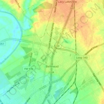
Name: Bellmead topographic map, elevation, terrain.

Location: Bellmead, McLennan County, Texas, 76705, United States (31.57291 -97.12324 31.63103 -97.06051)

Average elevation: 443 ft

Minimum elevation: 390 ft

Maximum elevation: 502 ft

McLennan County trails, hiking, mountain biking, running and outdoor activities

Other topographic maps

Click on a map to view its topography, its elevation and its terrain.

Wiggins

United States > Texas > McLennan County

Average elevation: 564 ft

Waco

United States > Texas > McLennan County > Waco

Average elevation: 492 ft

McGregor

United States > Texas > McLennan County > McGregor > McGregor

Average elevation: 715 ft

Bosqueville

United States > Texas > McLennan County > Waco > Bosqueville

Average elevation: 443 ft

Tehuacana Creek

United States > Texas > McLennan County > Neale

Average elevation: 394 ft

Speegleville

United States > Texas > McLennan County > Waco

Average elevation: 495 ft

Bruceville-Eddy

United States > Texas > McLennan County

Average elevation: 650 ft

Eddy

United States > Texas > McLennan County > Bruceville-Eddy

Average elevation: 692 ft

Gear up for your next adventure:

🏔️Mountain Trail Maps - High‑detail maps for popular peaks
🧼Biodegradable Camping Soap - Eco‑friendly soap for outdoor hygiene
🚑Emergency Bivvies - Heat-reflective sleeping bags for survival situations
📶Satellite Messenger - Communication device off‑grid
🌎3D Topographic Globes - Raised relief globes for a tactile understanding of geography

As an Amazon Associate, this site earns from qualifying purchases at no extra cost to you.