
Eisenberg topographic map
Interactive map
Click on the map to display elevation.
About this map
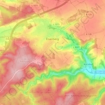
Name: Eisenberg topographic map, elevation, terrain.
Location: Eisenberg, Saale-Holzland-Kreis, Thuringia, 07607, Germany (50.93502 11.84657 50.98926 11.93293)
Average elevation: 1,001 ft
Minimum elevation: 650 ft
Maximum elevation: 1,204 ft
Other topographic maps
Click on a map to view its topography, its elevation and its terrain.
Hermsdorf
Germany > Thuringia > Saale-Holzland-Kreis
Hermsdorf, Saale-Holzland-Kreis, Thuringia, Germany
Average elevation: 1,112 ft