
Kleinglockner topographic map
Interactive map
Click on the map to display elevation.
About this map
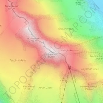
Name: Kleinglockner topographic map, elevation, terrain.
Average elevation: 10,226 ft
Minimum elevation: 7,710 ft
Maximum elevation: 12,096 ft
Other topographic maps
Click on a map to view its topography, its elevation and its terrain.
Pasterze
Österreich > Kärnten > Heiligenblut am Großglockner
Pasterze, Gamsgrubenweg, Heiligenblut am Großglockner, Spittal an der Drau, Kärnten, 9844, Österreich
Average elevation: 8,543 ft