
Wielki Giewont topographic map
Interactive map
Click on the map to display elevation.
About this map
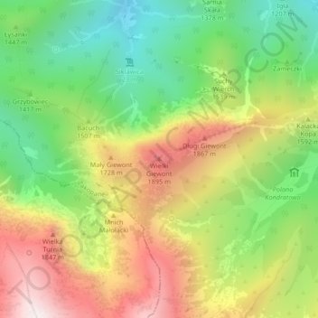
Name: Wielki Giewont topographic map, elevation, terrain.
Average elevation: 4,849 ft
Minimum elevation: 3,350 ft
Maximum elevation: 6,699 ft
Other topographic maps
Click on a map to view its topography, its elevation and its terrain.
Kurtkowiec
Poland > Lesser Poland Voivodeship > Tatra County > Zakopane
Kurtkowiec, Zakopane, Tatra County, Lesser Poland Voivodeship, Poland
Average elevation: 5,768 ft
Tatry
Poland > Lesser Poland Voivodeship > Tatra County > Zakopane
Tatry, Zakopane, Tatra County, Lesser Poland Voivodeship, Poland
Average elevation: 5,404 ft