
Sièges topographic map
Interactive map
Click on the map to display elevation.
About this map
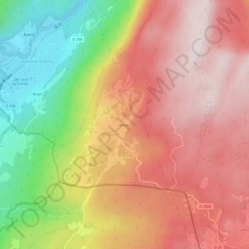
Name: Sièges topographic map, elevation, terrain.
Average elevation: 2,238 ft
Minimum elevation: 1,001 ft
Maximum elevation: 3,130 ft
Other topographic maps
Click on a map to view its topography, its elevation and its terrain.
Lac de Viry
France > Bourgogne-Franche-Comté > Jura > Viry
Lac de Viry, Viry, Saint-Claude, Jura, Bourgogne-Franche-Comté, France métropolitaine, 39360, France
Average elevation: 2,684 ft
Sous le Vernois
France > Bourgogne-Franche-Comté > Jura > Viry > Sous le Vernois
Sous le Vernois, Viry, Saint-Claude, Jura, Bourgogne-Franche-Comté, France métropolitaine, 39360, France
Average elevation: 2,700 ft