
Víziváros topographic map
Interactive map
Click on the map to display elevation.
About this map
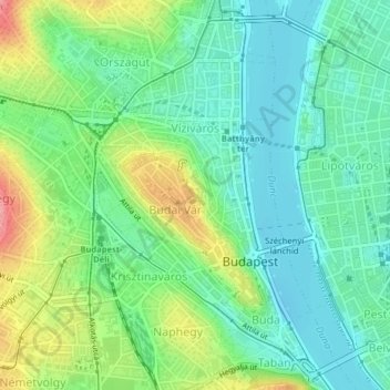
Name: Víziváros topographic map, elevation, terrain.
Location: Víziváros, 1. kerület, Budapest, Hongrie centrale, Hongrie (47.49317 19.02480 47.51180 19.04639)
Average elevation: 430 ft
Minimum elevation: 318 ft
Maximum elevation: 666 ft
Other topographic maps
Click on a map to view its topography, its elevation and its terrain.
XIV. kerület
XIV. kerület, Budapest, Hongrie centrale, Hongrie
Average elevation: 381 ft
XII. kerület
XII. kerület, Budapest, Hongrie centrale, Hongrie
Average elevation: 876 ft
V. kerület
V. kerület, Budapest, Hongrie centrale, Hongrie
Average elevation: 400 ft
Csúcs-hegy
Csúcs-hegy, Budapest, Hongrie centrale, 1285, Hongrie
Average elevation: 856 ft
Városliget
Városliget, 14. kerület, Budapest, Hongrie centrale, Hongrie
Average elevation: 371 ft
Terézváros
Terézváros, 6. kerület, Budapest, Hongrie centrale, Hongrie
Average elevation: 374 ft