
Thank you for supporting this site ❤️
Make a donation
Make a donation
Gear up for your next adventure:
As an Amazon Associate, this site earns from qualifying purchases at no extra cost to you.
Sinhagad topographic map
Click on the map to display elevation.
Thank you for supporting this site ❤️
Make a donation
Make a donation
Gear up for your next adventure:
As an Amazon Associate, this site earns from qualifying purchases at no extra cost to you.
About this map
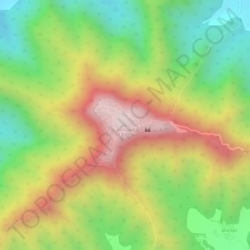
Name: Sinhagad topographic map, elevation, terrain.
Location: Sinhagad, Haveli, Maharashtra, 411025, India (18.36514 73.75494 18.36524 73.75504)
Average elevation: 3,261 ft
Minimum elevation: 2,267 ft
Maximum elevation: 4,321 ft
Thank you for supporting this site ❤️
Make a donation
Make a donation
Gear up for your next adventure:
As an Amazon Associate, this site earns from qualifying purchases at no extra cost to you.
Other topographic maps
Click on a map to view its topography, its elevation and its terrain.
Linear Garden, Pimple Saudagar
India > Maharashtra > Haveli > Pimpri-Chinchwad
Average elevation: 1,844 ft