
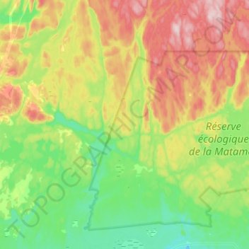
Rivière aux Rats Musqués topographic map
Interactive map
Click on the map to display elevation.
About this map
Name: Rivière aux Rats Musqués topographic map, elevation, terrain.
Average elevation: 568 ft
Minimum elevation: 0 ft
Maximum elevation: 1,519 ft
Other topographic maps
Click on a map to view its topography, its elevation and its terrain.
Lac-Labrie
Canada > Québec > Sept-Rivières > Sept-Îles
Lac-Labrie, Sept-Îles, Sept-Rivières, Côte-Nord, Québec, Canada
Average elevation: 331 ft
Lac des Rapides
Canada > Québec > Sept-Rivières > Sept-Îles
Lac des Rapides, Sept-Îles, Sept-Rivières, Côte-Nord, Québec, Canada
Average elevation: 653 ft
Lac Pioui
Canada > Québec > Sept-Rivières > Sept-Îles
Lac Pioui, Sept-Îles, Sept-Rivières, Côte-Nord, Québec, Canada
Average elevation: 420 ft