Geolocate

Moers topographic map

Click on the map to display elevation.

About this map

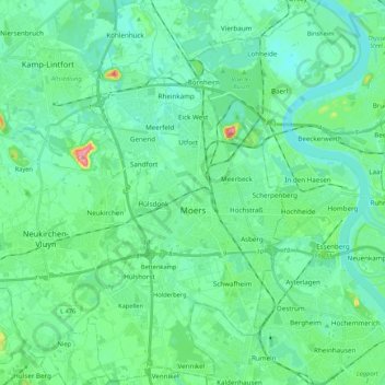
Name: Moers topographic map, elevation, terrain.

Location: Moers, Kreis Wesel, North Rhine-Westphalia, Germany (51.39080 6.55837 51.52378 6.67874)

Average elevation: 92 ft

Minimum elevation: 36 ft

Maximum elevation: 322 ft

Other topographic maps

Click on a map to view its topography, its elevation and its terrain.

Labbeck

Germany > North Rhine-Westphalia > Kreis Wesel

Average elevation: 141 ft

Gear up for your next adventure:

🧢Outdoor Hiking Hat - Sun protection hat for outdoor explorers
🧤Hiking Gloves - Protective gloves for rugged trails
🥤Water Filter Bottle - All‑in‑one filter bottle for safe hydration
🎒Hydration Pack - Hands‑free water reservoir for long hikes
🪶Multi‑Purpose Knife - Useful blade for camp and trail

As an Amazon Associate, this site earns from qualifying purchases at no extra cost to you.