
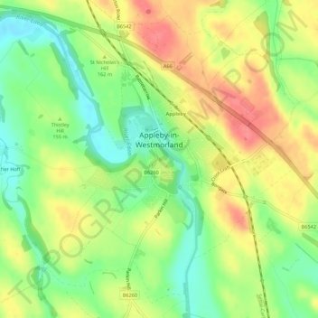
Appleby-in-Westmorland topographic map
Interactive map
Click on the map to display elevation.
About this map
Name: Appleby-in-Westmorland topographic map, elevation, terrain.
Average elevation: 509 ft
Minimum elevation: 394 ft
Maximum elevation: 630 ft
Other topographic maps
Click on a map to view its topography, its elevation and its terrain.
Alston
United Kingdom > England > Cumbria > Eden District
Alston, Eden District, Cumbria, England, CA9 3RF, United Kingdom
Average elevation: 1,325 ft
Brockleymoor
United Kingdom > England > Cumbria > Eden District > Plumpton
Brockleymoor, Hesket, Plumpton, Eden District, Cumbria, England, CA11 9NX, United Kingdom
Average elevation: 509 ft
Middleton
United Kingdom > England > Cumbria > Eden District
Middleton, Eden District, Cumbria, England, CA10 3UL, United Kingdom
Average elevation: 1,335 ft