
Alton topographic map
Interactive map
Click on the map to display elevation.
About this map
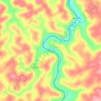
Name: Alton topographic map, elevation, terrain.
Location: Alton, Upshur County, West Virginia, United States (38.79927 -80.23397 38.83927 -80.19397)
Average elevation: 2,024 ft
Minimum elevation: 1,716 ft
Maximum elevation: 2,241 ft
Other topographic maps
Click on a map to view its topography, its elevation and its terrain.
Rock Cave
United States > West Virginia > Upshur County
Rock Cave, Upshur County, West Virginia, 26234, United States
Average elevation: 1,709 ft
Buckhannon
United States > West Virginia > Upshur County
Buckhannon, Upshur County, West Virginia, 26201, United States
Average elevation: 1,499 ft
South Buckhannon
United States > West Virginia > Upshur County > Buckhannon > South Buckhannon
South Buckhannon, Buckhannon, Upshur County, West Virginia, 26201, United States
Average elevation: 1,480 ft