
Cascais topographic map
Interactive map
Click on the map to display elevation.
About this map
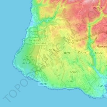
Name: Cascais topographic map, elevation, terrain.
Location: Cascais, Cascais e Estoril, Cascais, Lisbonne, Portugal (38.68937 -9.48655 38.74067 -9.40897)
Average elevation: 131 ft
Minimum elevation: -3 ft
Maximum elevation: 443 ft
Other topographic maps
Click on a map to view its topography, its elevation and its terrain.
Estoril
Portugal > Lisbonne > Cascais e Estoril > Galiza
Estoril, Galiza, Cascais e Estoril, Cascais, Lisbonne, Portugal
Average elevation: 161 ft