
Make a donation
Gear up for your next adventure:
As an Amazon Associate, this site earns from qualifying purchases at no extra cost to you.
Tietê topographic map
Click on the map to display elevation.
Make a donation
Gear up for your next adventure:
As an Amazon Associate, this site earns from qualifying purchases at no extra cost to you.
Tietê
Tietê is a Brazilian municipality in the state of São Paulo, located in the Metropolitan Region of Sorocaba, in the Meso-region of Piracicaba and in the Microregion of Piracicaba. It is located at latitude 23º06'07 "south and at a longitude 47º42'53" west, being at an altitude of 508 meters. Its estimated population in 2020 was 42,517 inhabitants. It has an area of 392,509 km2. This corresponds to a population density of 86.6 inhabitants/km2.
Make a donation
Gear up for your next adventure:
As an Amazon Associate, this site earns from qualifying purchases at no extra cost to you.
About this map
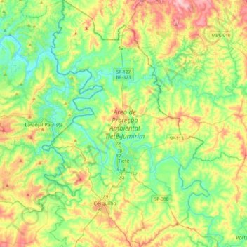
Name: Tietê topographic map, elevation, terrain.
Average elevation: 1,759 ft
Minimum elevation: 1,493 ft
Maximum elevation: 2,280 ft
Make a donation
Gear up for your next adventure:
As an Amazon Associate, this site earns from qualifying purchases at no extra cost to you.
Other topographic maps
Click on a map to view its topography, its elevation and its terrain.
Araçariguama
Brazil > São Paulo > Região Metropolitana de Sorocaba > Araçariguama > Araçariguama
Araçariguama is a city on the state of São Paulo in Brazil. It is part of the Metropolitan Region of Sorocaba. The population of city is of 22,860 (2020 est.) in an area of 145.20 km². The elevation is 695 m. Araçariguama was established in 1653.
Average elevation: 2,428 ft
Sorocaba
Brazil > São Paulo > Região Metropolitana de Sorocaba > Sorocaba
The terrain is classified as a wavy strands and characterized by local ridges, with an average altitude of 632 meters above the sea level. The highest altitude is 1028 meters, in the Serra de Sao Francisco. The lower altitude is 539 meters, in the valley of the Sorocaba River. Sorocaba is located on the edge…
Average elevation: 2,172 ft