
Spangenberg topographic map
Interactive map
Click on the map to display elevation.
About this map
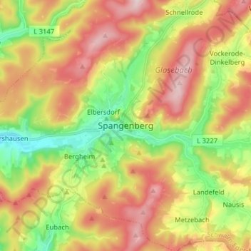
Name: Spangenberg topographic map, elevation, terrain.
Location: Spangenberg, Schwalm-Eder-Kreis, Hesse, 34286, Allemagne (51.07671 9.62672 51.15671 9.70672)
Average elevation: 1,155 ft
Minimum elevation: 650 ft
Maximum elevation: 1,706 ft
Other topographic maps
Click on a map to view its topography, its elevation and its terrain.
Schwalmstadt
Allemagne > Hesse > Schwalm-Eder-Kreis
Schwalmstadt, Frielendorf, Schwalm-Eder-Kreis, Hesse, 34613, Allemagne
Average elevation: 853 ft