
Oakdale topographic map
Interactive map
Click on the map to display elevation.
About this map
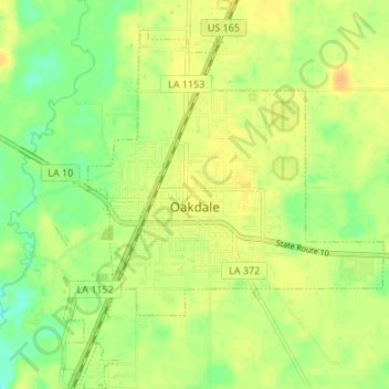
Name: Oakdale topographic map, elevation, terrain.
Location: Oakdale, Allen Parish, Louisiana, 71463, United States (30.78752 -92.67941 30.84558 -92.62356)
Average elevation: 112 ft
Minimum elevation: 59 ft
Maximum elevation: 148 ft
Other topographic maps
Click on a map to view its topography, its elevation and its terrain.
Kinder
United States > Louisiana > Allen Parish
Kinder, Allen Parish, Louisiana, 70648, United States
Average elevation: 46 ft
Grant
United States > Louisiana > Allen Parish > Grant
Grant, Allen Parish, Louisiana, 70644, United States
Average elevation: 105 ft