
Dranoutre topographic map
Interactive map
Click on the map to display elevation.
About this map
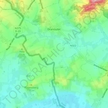
Name: Dranoutre topographic map, elevation, terrain.
Average elevation: 164 ft
Minimum elevation: 46 ft
Maximum elevation: 502 ft
Other topographic maps
Click on a map to view its topography, its elevation and its terrain.
Baneberg
Belgique > Flandre-Occidentale > Ypres > Heuvelland
Baneberg, Heuvelland, Ypres, Flandre-Occidentale, 8954, Belgique
Average elevation: 269 ft
La Clytte
Belgique > Flandre-Occidentale > Ypres > Heuvelland
La Clytte, Heuvelland, Ypres, Flandre-Occidentale, 8958, Belgique
Average elevation: 167 ft
Locre
Belgique > Flandre-Occidentale > Ypres > Heuvelland
Locre, Heuvelland, Ypres, Flandre-Occidentale, Flandre, 8958, Belgique
Average elevation: 240 ft
Mont Kemmel
Belgique > Flandre-Occidentale > Ypres > Heuvelland
Mont Kemmel, Heuvelland, Ypres, Flandre-Occidentale, 8956, Belgique
Average elevation: 223 ft
Kemmel
Belgique > Flandre-Occidentale > Ypres > Heuvelland
Kemmel, Heuvelland, Ypres, Flandre-Occidentale, Flandre, 8956, Belgique
Average elevation: 161 ft