
Tamazula de Victoria topographic map
Interactive map
Click on the map to display elevation.
About this map
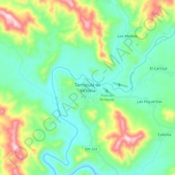
Name: Tamazula de Victoria topographic map, elevation, terrain.
Location: Tamazula de Victoria, Tamazula, Durango, México (24.92901 -107.00705 25.00901 -106.92705)
Average elevation: 1,135 ft
Minimum elevation: 653 ft
Maximum elevation: 2,234 ft
Other topographic maps
Click on a map to view its topography, its elevation and its terrain.
Río Tamazula
México > Durango > Tamazula > El Carrizal
Río Tamazula, El Carrizal, Tamazula, Durango, México
Average elevation: 1,047 ft