
Salmo topographic map
Interactive map
Click on the map to display elevation.
About this map
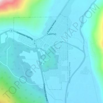
Name: Salmo topographic map, elevation, terrain.
Average elevation: 2,346 ft
Minimum elevation: 2,123 ft
Maximum elevation: 4,029 ft
Other topographic maps
Click on a map to view its topography, its elevation and its terrain.
Lardeau
Canada > Colombie-Britannique > Regional District of Central Kootenay > Area D (Lardeau Valley/Duncan Lake)
Lardeau, Area D (Lardeau Valley/Duncan Lake), Regional District of Central Kootenay, Colombie-Britannique, V0G 1B0, Canada
Average elevation: 2,464 ft
Kootenay Lake Provincial Park - Coffee Creek Site
Canada > Colombie-Britannique > Regional District of Central Kootenay > Area D (Lardeau Valley/Duncan Lake)
Kootenay Lake Provincial Park - Coffee Creek Site, Area D (Lardeau Valley/Duncan Lake), Regional District of Central Kootenay, Colombie-Britannique, Canada
Average elevation: 2,297 ft
Area C
Canada > Colombie-Britannique > Regional District of Central Kootenay > Area C
Area C, Regional District of Central Kootenay, Colombie-Britannique, V0B 1G7, Canada
Average elevation: 4,695 ft
Castlegar
Canada > Colombie-Britannique > Regional District of Central Kootenay
Castlegar, Regional District of Central Kootenay, Colombie-Britannique, Canada
Average elevation: 2,726 ft