
Town of Mountain topographic map
Interactive map
Click on the map to display elevation.
About this map
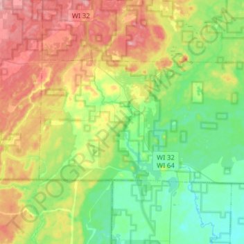
Name: Town of Mountain topographic map, elevation, terrain.
Location: Town of Mountain, Oconto County, Wisconsin, United States (45.11380 -88.55933 45.20387 -88.30877)
Average elevation: 994 ft
Minimum elevation: 817 ft
Maximum elevation: 1,286 ft
Other topographic maps
Click on a map to view its topography, its elevation and its terrain.
Town of Oconto
United States > Wisconsin > Oconto County
Town of Oconto, Oconto County, Wisconsin, United States
Average elevation: 633 ft
Winslow Lake 3WR1017 Dam
United States > Wisconsin > Oconto County
Winslow Lake 3WR1017 Dam, Town of Riverview, Oconto County, Wisconsin, United States
Average elevation: 1,201 ft
Copper Culture State Park
United States > Wisconsin > Oconto County > Oconto
Copper Culture State Park, US 41, Oconto, Oconto County, Wisconsin, 54153, United States
Average elevation: 604 ft
Suring
United States > Wisconsin > Oconto County
Suring, Oconto County, Wisconsin, United States
Average elevation: 814 ft
Lakewood
United States > Wisconsin > Oconto County
Lakewood, Town of Lakewood, Oconto County, Wisconsin, 54138, United States
Average elevation: 1,286 ft
Town of Little Suamico
United States > Wisconsin > Oconto County
Town of Little Suamico, Oconto County, Wisconsin, 54171, United States
Average elevation: 650 ft
Lena
United States > Wisconsin > Oconto County
Lena, Oconto County, Wisconsin, 54139, United States
Average elevation: 702 ft
Green Bay West Shores Wildlife Area-Oconto Marsh Unit
United States > Wisconsin > Oconto County > Oconto
Green Bay West Shores Wildlife Area-Oconto Marsh Unit, Oconto, Town of Little River, Oconto County, Wisconsin, United States
Average elevation: 587 ft
Town of Riverview
United States > Wisconsin > Oconto County
Town of Riverview, Oconto County, Wisconsin, 54149, United States
Average elevation: 1,073 ft
Trout Lake
United States > Wisconsin > Oconto County
Trout Lake, Town of Doty, Oconto County, Wisconsin, United States
Average elevation: 1,289 ft
Green lake
United States > Wisconsin > Oconto County > Town of Mountain
Green lake, Town of Mountain, Oconto County, Wisconsin, United States
Average elevation: 919 ft
Maiden Lake
United States > Wisconsin > Oconto County
Maiden Lake, Town of Riverview, Oconto County, Wisconsin, United States
Average elevation: 1,227 ft
Townsend
United States > Wisconsin > Oconto County > Townsend
Townsend, Town of Townsend, Oconto County, Wisconsin, 54175, United States
Average elevation: 1,345 ft
Gillett
United States > Wisconsin > Oconto County
Gillett, Oconto County, Wisconsin, United States
Average elevation: 830 ft