
Und topographic map
Interactive map
Click on the map to display elevation.
About this map
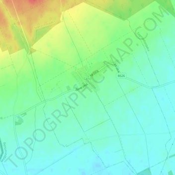
Name: Und topographic map, elevation, terrain.
Average elevation: 702 ft
Minimum elevation: 646 ft
Maximum elevation: 810 ft
Other topographic maps
Click on a map to view its topography, its elevation and its terrain.
Salamonfa
Hongrie > Győr-Moson-Sopron vármegye > Zsira
Salamonfa, Zsira, Soproni járás, Győr-Moson-Sopron vármegye, Transdanubie occidentale, Transdanubie, 9476, Hongrie
Average elevation: 653 ft
Ravazd
Hongrie > Győr-Moson-Sopron vármegye
Ravazd, Pannonhalmi járás, Győr-Moson-Sopron vármegye, Transdanubie occidentale, Transdanubie, 9091, Hongrie
Average elevation: 679 ft
Bezi
Hongrie > Győr-Moson-Sopron vármegye
Bezi, Győri járás, Győr-Moson-Sopron vármegye, Transdanubie occidentale, Transdanubie, 9162, Hongrie
Average elevation: 371 ft