
Make a donation
Gear up for your next adventure:
As an Amazon Associate, this site earns from qualifying purchases at no extra cost to you.
Ewing Township topographic map
Click on the map to display elevation.
Make a donation
Gear up for your next adventure:
As an Amazon Associate, this site earns from qualifying purchases at no extra cost to you.
Ewing Township
The highest elevation in Ewing Township is 225 feet (69 m) AMSL just east of Interstate 95 and just west of Trenton-Mercer Airport, while the lowest point is just below 20 feet (6.1 m) AMSL along the Delaware River near the border with Trenton.
Make a donation
Gear up for your next adventure:
As an Amazon Associate, this site earns from qualifying purchases at no extra cost to you.
About this map
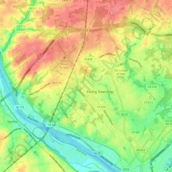
Name: Ewing Township topographic map, elevation, terrain.
Location: Ewing Township, Mercer County, New Jersey, United States (40.23284 -74.85657 40.29221 -74.74881)
Average elevation: 125 ft
Minimum elevation: 13 ft
Maximum elevation: 240 ft
Mercer County trails, hiking, mountain biking, running and outdoor activities
Make a donation
Gear up for your next adventure:
As an Amazon Associate, this site earns from qualifying purchases at no extra cost to you.
Other topographic maps
Click on a map to view its topography, its elevation and its terrain.
East Trenton Heights
United States > New Jersey > Mercer County > Hamilton Township
Average elevation: 72 ft
Green Curve Heights
United States > New Jersey > Mercer County > Ewing Township
Average elevation: 131 ft
Make a donation
Gear up for your next adventure:
As an Amazon Associate, this site earns from qualifying purchases at no extra cost to you.
Robbinsville
United States > New Jersey > Mercer County > Robbinsville Township
Average elevation: 105 ft
Make a donation
Gear up for your next adventure:
As an Amazon Associate, this site earns from qualifying purchases at no extra cost to you.
Hillside Terrace
United States > New Jersey > Mercer County > Robbinsville Township
Average elevation: 115 ft
Make a donation
Gear up for your next adventure:
As an Amazon Associate, this site earns from qualifying purchases at no extra cost to you.
Coopers Corner
United States > New Jersey > Mercer County > Hopewell Township
Average elevation: 341 ft
Hamilton Square
United States > New Jersey > Mercer County > Hamilton Township
Average elevation: 95 ft
Make a donation
Gear up for your next adventure:
As an Amazon Associate, this site earns from qualifying purchases at no extra cost to you.