
La Rue topographic map
Interactive map
Click on the map to display elevation.
About this map
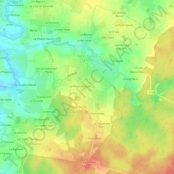
Name: La Rue topographic map, elevation, terrain.
Average elevation: 223 ft
Minimum elevation: 121 ft
Maximum elevation: 331 ft
Other topographic maps
Click on a map to view its topography, its elevation and its terrain.
L'Abbaye de Saint-Sulpice
France > Brittany > Ille-et-Vilaine > Saint-Sulpice-la-Forêt
L'Abbaye de Saint-Sulpice, Saint-Sulpice-la-Forêt, Rennes, Ille-et-Vilaine, Brittany, Metropolitan France, 35250, France
Average elevation: 223 ft